Across the Space Frontier - Space Station Orbit 2
Across the Space Frontier, Joseph Kaplan, Wernher von Braun, Heinz Haber, Willey Ley, Oscar Schatchter, Fred Whipple, edited by Cornelius Ryan, Viking Press, 1952.
I tried to understand the space station’s orbit with numerical integration.
Code repo, go look at it, see if you like my code.
I have previously misunderstood von Braun’s space station orbit in at least two different ways.
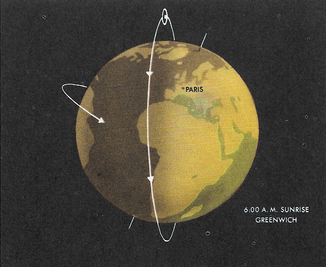
Von Braun and company have their space station in a 66.5° inclination, circular orbit. It is not a polar orbit, merely a high-inclination circular orbit.
Since the earth itself is inclined 23.5° to the plane of it’s orbit, a 66.5° inclination puts von Braun’s space station in an orbit inclined 90° to the ecliptic.

The graphics illustrating the orbit in Across the Space Frontier clearly show this, but the text doesn’t give a good reason, nor is 90° inclination to the ecliptic explicitly mentioned. Given the extensive discussion of “precession of the nodes” complete with 2 graphics in Conquest of the Moon, I find it hard to believe von Braun and company didn’t have some idea of why they decided on an orbit normal to the plane of the ecliptic, but no explanations appear in these famous early 1950s books.
The space station has an explicitly military purpose (raining atomic bombs on obstreperous commies), but I don’t see any reason why that demands a 66.5° inclination. It’s not in a sun synchronous orbit. In The Conquest of the Moon, von Braun says that it takes 220 days for Precession of the Nodes to cause a 360° “rotation” of the orbit. Even with that effect, the orbit doesn’t allow the space station to always gyroscopically point its solar power mirrors at the sun.
It’s possible that eliminating useless time over the polar ice caps was a consideration. The similarity in inclination to molniya orbits, which have 63.4° inclination, makes me think that was the reason. Careful choice of orbit injection could give a longer flight time over the then USSR.
I decided to investigate what the ground track of the space station might have looked like, starting with first principles, like Newton’s second law, F = mA, and Newton’s law of universal gravitation, F = Gm1m2/r2. I wrote a completely Newtonian, geocentric simulation. I did not account for the earth’s oblateness causing Precession of the Nodes.
Numerical Integration of Space Station’s Orbit
for t := t0; t < tmax; t += Δt {

    // find distance from center of earth, which is at (0.0,0.0,0.0)
    r = √(X*X + Y*Y + Z*Z)

    // magnitude of attraction due to gravity
    Fgrav = G Mearth/(r*r)

    // X, Y, Z direction components
    // of gravitational force
    Fx = (-X/r)Fgrav
    Fy = (-Y/r)Fgrav
    Fz = (-Z/r)Fgrav

    // Vector acceleration components
    Ax = Fx/M
    Ay = Fy/M
    Az = Fz/M

    // Increment velocity components
    Vx += Ax Δt
    Vy += Ay Δt
    Vz += Az Δt

    // Increment position components
    X += Vx Δt
    Y += Vy Δt
    Z += Vz Δt
}
This is the most simplistic numerical integration. It’s one sophistication is that it’s “symplectic”. Basically the programmer has a choice of when to calculate acceleration and velocity components: at the beginning of the time step or at the end of it, after the satellite has had its position updated.
I chose to calculate acceleration and velocity at the beginning of the time step, updating the satellite’s position based on those freshly calculated components. It turns out this is called “symplectic integration”. It works better numerically than updating the satellite’s position then figuring out acceleration and velocity components.
This amounts to the difference between (the vector versions of):
- Xi+1 = Xi + A(Xi)Δt2
- Xi+1 = Xi + A(Xi-1)Δt2
Ground Track on non-rotating earth
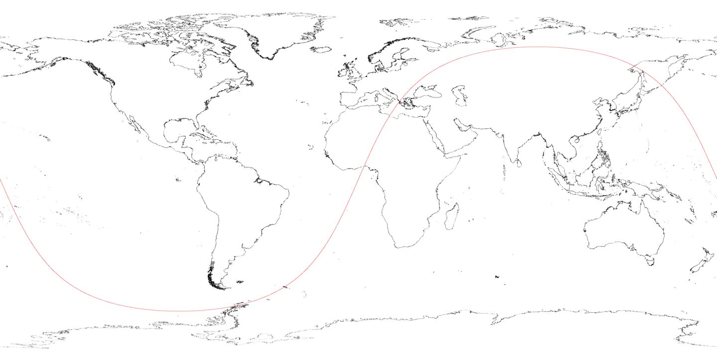
After fooling around a bit to get a 66.5° inclination, and finding out that a 1075 mile height orbit is more like 2 hours and 58 seconds, I got a decent ground track of von Braun’s space station on a non-rotating earth.

The calculation starts with the space station directly overhead of 0° west, 0° north, with velocity components in Y (towards east) and Z (towards north) directions. The space station heads northeast from 0°, 0°, reaching 66.5° north over Siberia, and 66.5° south over the South Pacific southwest of the Cape Horn.
The map projection is using (longitude,latitude) as (X,Y) Cartesian coordinates.
That’s actually 24 hours of orbiting. The ground track lines up very closely, which is good. The numerical integration isn’t losing energy or leaking motion from one axis to the other.
I’m a little surprised by the ground track: it looks like an old X11 “sunclock” app that showed night and day on a map projection. That makes sense, as the sun illuminates half the earth at once, so the day/night dividing line is conceptually similar to a circular orbit’s ground track.
Ground Track on rotating earth

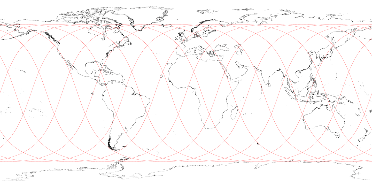
24 hours of orbiting, ground track on a rotating earth.
The map projection is using (longitude,latitude) as (X,Y) Cartesian coordinates.
I modeled the earth’s rotation by calculating (X,Y,Z) orbit coordinates, and converting them to (longitude, latitude).
longitude = tan-1(Y/X)
latitude = tan-1(Z/√(X2 + Y2))
I used the Go programming language’s math.Atan2() function to get the
“north is positive latitude, south is negative latitude” convention correct.
I calculated how far the earth had rotated at the time of the (X,Y,Z) coordinates,
and mapped that back to a (-180, 180) degree rotation via the Go programming language’s
math.Remainder() function.
Very convenient that math.Remainder() worked so well.
I subtracted that value (between -180 and 180) from the longitude calculated
from the space station’s (X,Y,Z) coordinates to determine what longitude
the space station was directly overhead.
The ground track has 24 crossings of the equator, which makes sense. The orbit has a period of 2 hours, crossing the equator twice per orbit, once going north-to-south, once south-to-north.
At 24 hours of simulation, the ground track returns to 0° N, 0° W. That’s good, it shows that my simulation of the earth’s rotation is exact enough so that 12, 2 hour orbits make it back to the start. The sixth orbit crosses the equator at 180° W (or 180° E), as well.
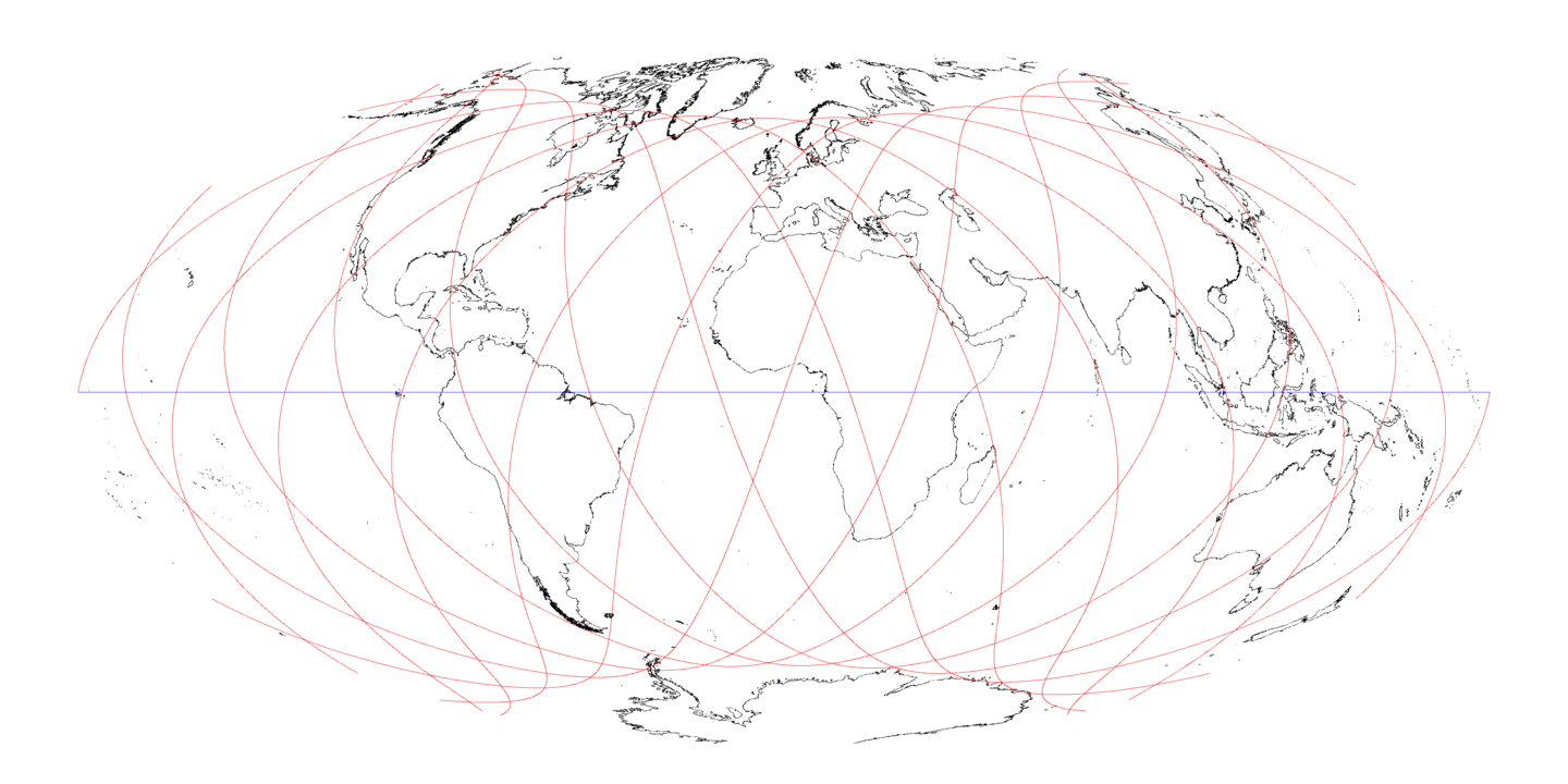
Hammer Projection Ground Track on rotating earth

Above, a Hammer map projection of the earth with 24 hours of ground track drawn on it. This projection gives you more of a sense of high latitude coverage. The ground tracks at high latitude are close together. Looks like the ground track doesn’t cover Murmansk and the Kola peninsula. The USSR’s main nuclear submarine port is on the Kola peninsula, this undermines the hypothesis that the inclination was chosen for better views of the USSR. To be fair to von Braun, the first nuclear submarine was launched in 1954, so he may not have considered them.
